Caspian Sea, Central Asian seismicity and seismic hazard

TEHRAN - The collision of the Eurasian and Arabian tectonic plates causes tectonic interaction with significant seismic activity along fault systems in the Alborz Mountains and the Caspian Sea region.
The Alborz Mountain belt is a major seismogenic zone with active faults like the North Alborz Fault and Mosha Fault. These faults extend from Jajarm (east) to the Aras River (northwest), affecting cities such as Damghan, Semnan, Tehran (Rey), Qazvin, and Ardabil.
In the Caspian southern coast, the high-risk areas like Ramsar and Rasht lie near the Talesh-Mughan Fault. The Alborz-Caspian boundary is prone to great earthquakes due to a compressional tectonic regime.
- Major historical earthquakes
Damghan (856 AD) is the greatest historical event to be known as the deadliest earthquake (M~7.9), killing some 200,000 people. It devastated the Silk Road city of Qumis (near modern Damghan), highlighting seismic risks along ancient trade routes.
743 Caspian Gates Earthquake: Recorded in Byzantine sources, this event occurred near Derbent (Russia) or Talesh (Iran). Its magnitude remains debated, but its documentation highlights long-standing seismic activity in the Caspian region 4.
Jorjan/Gonbad Kavus (958 AD): A destructive earthquake damaged the iconic Gonbad Kavus tower, underscoring long-term seismic activity in northeastern Iran.
Manjil (20 June 1990): M7.3 earthquake near Rasht and Rudbar killed some 16,000, collapsing infrastructure and underscoring vulnerability in the Alborz-Caspian transition zone.
Ardabil (28 Feb 1997): M6.1 quake near Meshkinshahr killed some 1,500, linked to the Sabalan volcanic region and the Alborz-Azerbaijan seismic zone.
Talesh and Caspian Region: Recurrent activity, including a 2012, M6.4 Varzeghan earthquake near the Azerbaijan-Iran border, tied Ahar Fault.
- Ancient roads and seismic zones
Silk Road Corridors passing through cities like Damghan, Semnan, Rey (Tehran), and Qazvin were critical seismic zones along or near active faults.
The 856 Qumis (Damghan) earthquake exemplifies seismic threats to these routes. Eastern Alborz to the Caspian region, traversing fault zones where the historical earthquakes in Jajarm and Gonbad reflected their seismic activity.
The Ardabil area seismic zones are recently represented by 28 February 1997 Golestan Ardabil M6.1 earthquake.
Rapid urbanization in the Caspian coasts from Astara to Rasht, Ramsar, Chalus, Nur, and Behshahr, developed along the northern foothills of the Alborz Belt, has increased earthquake risk due to higher exposure relating to a larger accumulation of populations. Poor construction practices exacerbate risks.
Mosha and North Alborz faults in the southern Alborz belt are seismically active due to the Alborz-Caspian tectonic regime, with historical earthquakes impacting ancient and modern settlements alike.
Ancient roads (Silk Road) align with fault systems, exposing historic cities to repeated seismic events. Ongoing monitoring and retrofitting of infrastructure are vital for mitigating risks in culturally and economically significant zones.
The ancient trade networks and modern seismic hazards emphasize the interplay between natural forces and human settlement in Iran’s volatile northern regions.
The southern Caspian Sea coast lies within the Alborz seismic zone, where active faults like the Mazandaran, Alborz, Lahijan, and Astara generate frequent earthquakes. These faults are part of the broader collision between the Eurasian and Arabian plates.
The region is prone to liquefaction, landslides, and subsidence due to soft sedimentary soils and high groundwater levels, exacerbating seismic risks
The Caspian coastal plain, particularly areas like Golestan and Mazandaran provinces, remains highly vulnerable to earthquakes of up to M5 due to active faulting and dense population. Recent probabilistic models integrate macroseismic data to assess hazard intensity.
These highlight discrepancies between historical records and current risk maps, urging improved preparedness in cities near active faults like Tehran.
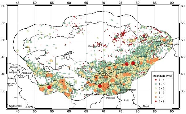
- Central Asia
Central Asia’s seismicity is driven by the India-Eurasia collision, with major fault systems in the Tien Shan, Pamir, and Dzhungarian regions. The Dzhungarian Fault in Kazakhstan shows evidence of prehistoric earthquakes up to Mw8.4.
The most important historical Earthquakes known in the Central Asian region:
6 October 1948 Ashgabat Earthquake (Mw7.3): Destroyed Turkmenistan’s capital, in the SSR of the Soviet Union, killing some 110,000.
10 July 1949 Khait Earthquake (Mw7.5) in Gharm Oblast of the Tajik SSR of the Soviet Union, caused around 7200 victims and triggered massive landslides in Tajikistan, burying entire villages.
Prehistoric Mega-Events: Paleoseismic studies reveal recurrent large quakes (e.g., Mw8.4 on the Dzhungarian Fault), underscoring the region’s capacity for catastrophic ruptures.
Faults beneath cities like Almaty (Kazakhstan) and Dushanbe (Tajikistan) pose direct threats. The Zailisky Range front Fault near Almaty has ruptured twice in the past 10,000 years.
Improving resilience in these regions requires updated building codes, public education, and integration of historical data into modern seismic models to address vulnerabilities.
The historical seismicity of Iran Caspian Sea, and Central Asia underscores the persistent threat posed by active tectonics. While advancements in hazard assessment offer improved risk insights, socio-political and infrastructural challenges remain critical barriers to disaster resilience.
Future efforts must prioritize interdisciplinary collaboration and community engagement to mitigate these risks effectively.
Leave a Comment